By Mariah Cannon

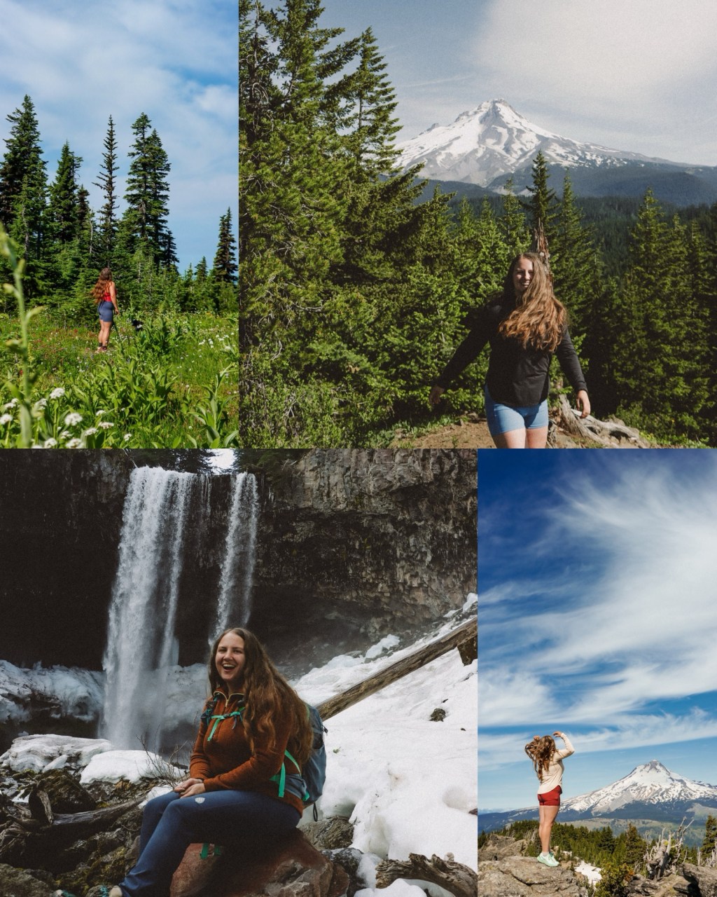
The Mt. Hood area has to be one of Oregon’s most unique, diverse, and absolutely stunning wilderness areas to explore. Offering over 279,000 acres of area to hike, swim, paddle, bike, and more – there’s no doubt it’s an outdoorsy persons dream!
I spend a lot of time hiking and frolicking around in this area, so I figured I would create a list of the best hiking trails for you to add to your list this summer! Ranked in no particular order, here they are!
Most or all of these trails require the Northwest Forest Pass, so be sure to have yours in order to avoid a fine from a ranger!
Disclaimer: This blog post contains affiliate links. If you choose to purchase something after clicking on one of the links, I earn a small commission at no additional cost to you. This helps me keep building my dream life and is a simple way to support your favorite creatives.

Table of Contents
- Table of Contents
- 1. Palmeteer Point & Twin Lakes Loop
- 2. Ramona Falls
- 3. Lookout Mountain
- 4. Tamanawas Falls
- 5. Tom, Dick, & Harry Mountain
- 6. Burnt Lake
- 7. McNeil Point
- 8. Elk Meadows
- 9. Sahale and Umbrella Falls
- 10. Little Zig Zag Falls
1. Palmeteer Point & Twin Lakes Loop

Distance: 10 miles round-trip
Elevation: 1,581 feet
Hike Type: Lollipop Loop
Difficulty: Moderate
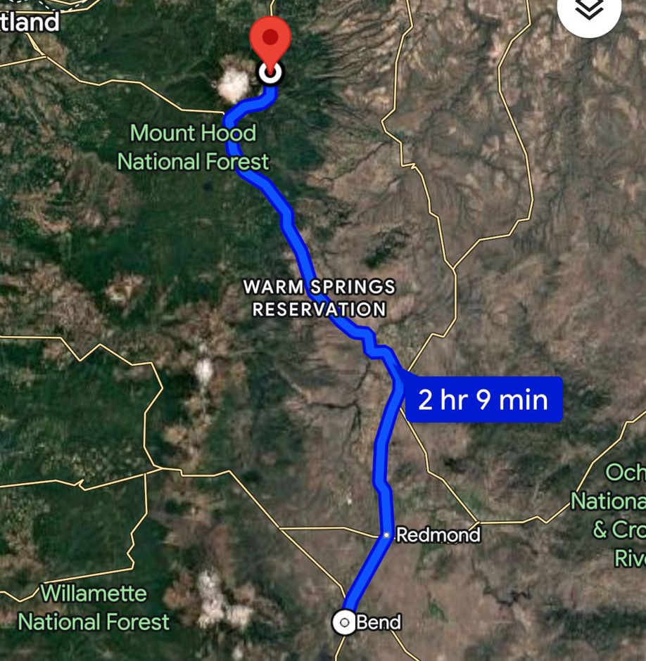
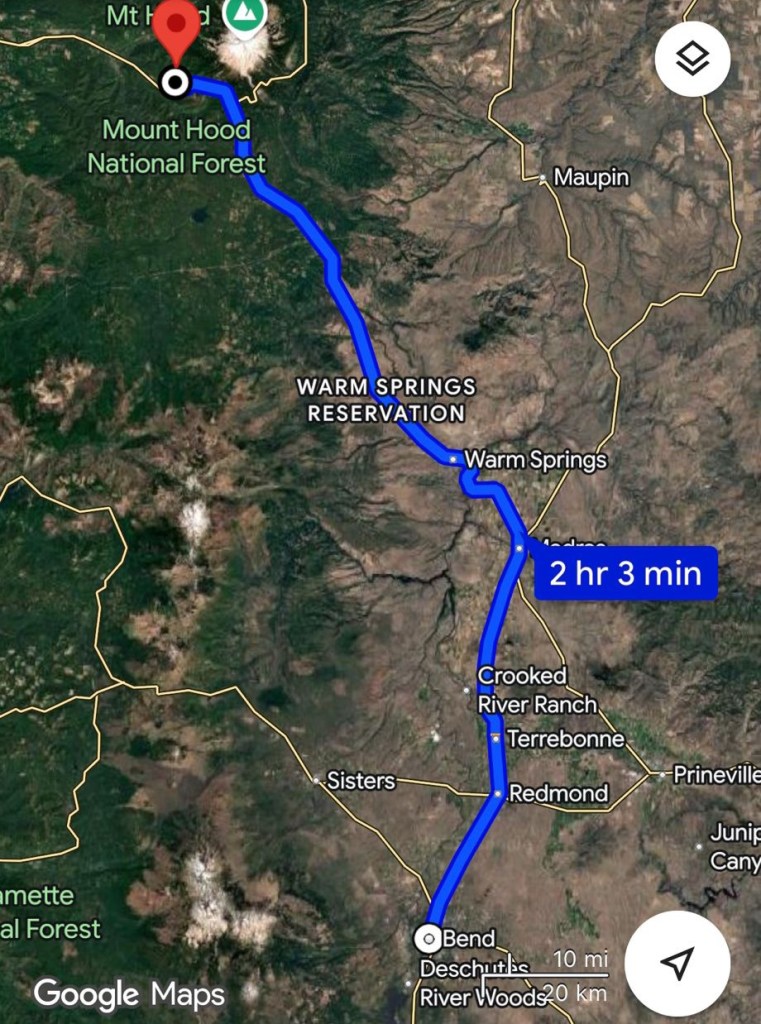
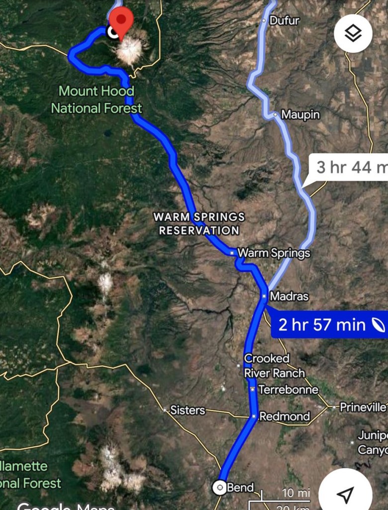
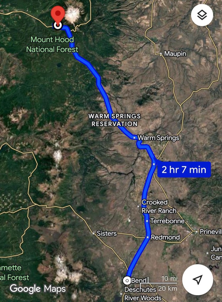
Getting there from Bend, Oregon: Head North on US-97 for 103 miles, from there make a slight right onto OR-35 to Hood River for approximately 2 miles then turn right onto FS-3531 where you’ll park at the Barlow Pass sno-park lot and begin your hike.

Final thoughts:
All I could say this entire trail was, “WOW”. It is so unique in so many ways – you cross so many different ecosystems and it feels like straight out of a book. I recommend doing the loop clockwise and hitting Palmeteer Point first before it gets too hot, that side is more exposed than the other side of the loop. It’s nice, cool, and shaded on the second half of the loop. If you’re looking for an easier backpacking trail that helps get some mileage in, this would be a great option. You can camp at both Upper and Lower Twin lakes and the lower lake is a bit larger with a pit toilet there and plenty of space to set up camp.
We seen a few people backpacking when we did this hike. It was completely snow free June 12th, 2025. That varies with snow pack and weather each year, be sure to check recent reviews before you go out!
My favorite way to do that is on Alltrails and you can get your first year for 30% off!

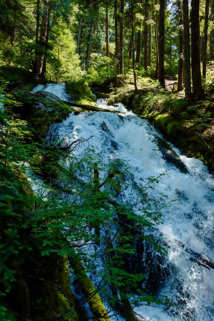
2. Ramona Falls

Distance: 7.7 miles round-trip
Elevation: 1,066 feet
Hike Type: Lollipop loop
Difficulty: Moderate (difficult river crossing)
Getting there from Bend, Oregon: Head North on US-97 for approximately 116 miles then turn right onto East Lolo Pass road and continue for 4 miles before turning on Muddy Fork road or NF-1825 for 1.7 miles then take a left on NF-100 and in about .3 of a mile, turn left onto a very tough FS-100 and in a quarter of a mile you’ll reach the parking lot.

Final thoughts:
The trail itself is not super steep or difficult in any specific area, however there is a sketchy river crossing and the river is moving very quickly here. Best practice is to use a stick or hiking poles if there is not a stable log to cross or scoot on. It’s not recommended for dogs, however I did take my 50lb husky/collie mix and had to carry him over one section and we did fine. Know both your dog and your own abilities and use your best judgement. This trail is so beautiful, especially during early-mid summer when everything is green and in bloom! If you do it as a loop, make sure to go counter clockwise so you have less time from the waterfall back to the lollipop!
3. Lookout Mountain

Distance: 3 miles round-trip
Elevation: 568 feet
Hike Type: Out and back
Difficulty: Easy-Moderate
Getting there from Bend, Oregon: Head North on US-97 for 107 miles before making a slight right onto OR-35 towards Hood River and continue for 13 miles and turn to the right onto Lookout Mountain Road. Continue for 4.5 miles on a relatively rough gravel road and make another right onto FS-4410 and lastly directly after turn right onto Bennett Pass Rd/NF-3550 and in almost a mile you’ll see the parking lot on the left and some gorgeous meadows of wildflowers if you go at the right time of year! You will need a Northwest Forest Pass here.

Final thoughts:
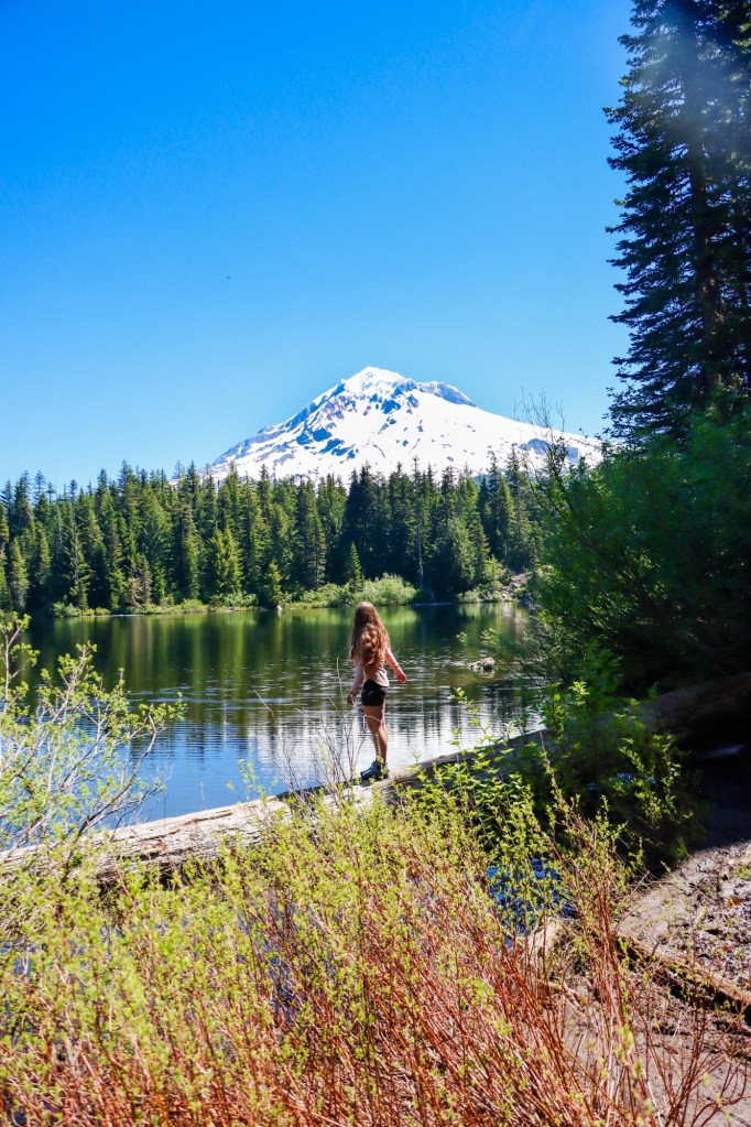
Wow. Wow. Wow. This is such a short and rewarding trail, my goodness! Only 1.5ish up and Mt. Hood is practically sitting in your lap. I can’t believe how long it took me to do this trail! We went June 20th, 2025 and there was still quite a few large snow patches that were easy to pass and maneuver around, but the wildflowers were darn near peak bloom. No mosquitoes either thankfully. Once you reach the summit, obviously the star of the show is Mt. Hood – but you also have Adams, Helens, Rainier, the Three Sisters, and Mt. Jefferson. I could’ve cried it was so pretty. If you only have time for one hike in the area, make it this one. You will not be disappointed.
4. Tamanawas Falls

Distance: 4.7 miles round-trip
Elevation: 600 feet
Hike Type: Out and back
Difficulty: Easy-Slightly moderate
Getting there from Bend, Oregon: Head North on US-97 for 107 miles until you get to the OR-35 turn off to your right. From there you’ll continue for 15 miles until you reach the parking lot right off the road on the left.
Final thoughts
Tamanawas is gorgeous, but it’s a popular area! If you plan on getting there on any given day later than 10am, you will struggle to find parking. I suggest going as early as possible to avoid crowds, heat, and dealing with parking situations. You do need a Northwest Forest Pass here as well.
5. Tom, Dick, & Harry Mountain

Distance: 8 miles round-trip
Elevation: 1,709 feet
Hike Type: Out and back
Difficulty: Moderate-Difficult
Getting there from Bend, Oregon: Head North on US-97 for about 110 miles and you’ll pass government camp and find the parking lot on your left where it says, “Mirror Lake Trailhead”.

Final thoughts:
This is one of the most bang for your buck hikes! BUT with that being said, it gets busy and get’s a lot of attention, however most people only go to Mirror lake – which is about 2 miles in. Make sure to go early to avoid a filled parking lot and heavy crowds. You can stay overnight at the lake as well, and it is so stunning! I have heard about many cars getting broken into here, but myself nor none of the gals I’ve lead here have had that sort of experience. Just make sure to keep all your valuables on your person.
6. Burnt Lake
Distance: 7 miles round-trip
Elevation: 1,463 feet
Hike Type: Out and back
Difficulty: Moderate
Getting there from Bend, Oregon: Head North on US-97 for about 110 miles and then turn right onto Twin Bridges Rd for about a quarter of a mile before turning left onto E rd 35 and the parking area should be about a quarter of a mile up.
Final thoughts:
I had no idea this trail was here! It is 100% so stunning and I highly recommend stopping by if possible. You’ll find less people than some of the other trails around Mt. Hood, but still get incredible forest views, a stunning lake, and more!
7. McNeil Point

Distance: 9.3 miles round-trip
Elevation: 3,356 feet
Hike Type: Lollipop loop
Difficulty: Hard
Getting there from Bend: Begin North on US-97 for about 116 miles and then turn right onto E Lolo Pass Rd and follow it for 4.2 miles then turn right onto Muddy Fork Rd, continue straight on that road for a little over 7 miles and you’ll come to the incredibly small parking area for the Top Spur trailhead. There’s only a few spots to actually park and then most people end up alongside the road. If you do have to park along the road, make sure you’re as much out of the way as possible. I highly recommend getting here as early as possible to avoid having to do that! You will fill out a self issue permit a little ways into the trail.
Final Thoughts:
In my opinion, this trail was hard and I don’t know if I was just having an off day or not fueled up properly, but I about died. However, I guess you do gain about 1,000 feet/mile so it is pretty strenuous! I specifically did this trail to find magenta paint brush to photograph for my grandma (our favorite wildflower is Indian Paint brush) and to my surprise, there was plenty of it! You come up to a boulder field with a small plateau with tons of wildflowers! For reference, I hiked it in July of 2024, flower blooms are different every year depending on snow levels and weather conditions.
8. Elk Meadows

Distance: 5.5 miles round-trip
Elevation: 1,085 feet
Hike Type: Lollipop loop
Difficulty: Moderate
Getting there from Bend: Head North on US-97 for about 102 miles and then take exit 35 towards Hood River, after 7.2 miles turn left on to the Elk Meadows Trailhead road and the parking area will be a little over a quarter mile up on the right hand side.

Final Thoughts:
Wow. When there’s a Lupine super bloom, this trail will absolutely blow your mind!! I had no idea it would be this stunning in July! There is a small, but sketchy river crossing. I had to carry Maverick across a section of it. Be sure to use a stick or hiking poles and unclip your backpack in case of any slipping!
9. Sahale and Umbrella Falls

Distance: 4.4 miles round-trip
Elevation: 921 feet
Hike Type: Loop
Difficulty: Moderate
Getting there from Bend: Begin North on US-97 for 102 miles before turning onto OR-35 towards Hood River. Then after 5.8 miles, take the exit towards Bennet Pass and in 1.6 miles, you’ll turn right into the Parking lot.

Final Thoughts:
This is a fun trail for anyone! In the late Spring, you get really awesome flower blooms and in the Fall, all the huckleberry bushes turn bright red, along with other color changing plants and trees and it is beautiful! In the Fall, there are lots of hunters in the area so keep that in mind that you’ll more than likely cross paths with them.
10. Little Zig Zag Falls
Distance: .6 miles round-trip
Elevation: 101 feet
Hike Type: Out & Back
Difficulty: Easy
Getting there from Bend, Oregon: Head North on US-97 for 110 miles before turning right onto 39 road and your destination will be 2.2 miles down the road to a large parking lot.
Final thoughts:
I never knew this was a trail, lead alone a waterfall. It’s a super great, easy walk to the falls. On a Summer day, you’ll find lots of people, but if you go early in the day – you’ll find a little bit of solitude.

Enjoy this guide to some of Mt. Hood’s best trails? Be sure to save it for future adventures!
Let’s Get Adventuring!
Mariah 🙂


Leave a comment